From Inductive Loops to LiDAR Solutions: The Future of City Traffic Monitoring
With Inductive Loops' limitations becoming increasingly evident, LiDAR solutions are quickly becoming the next wave for city traffic monitoring

Traffic sensors are essential tools for cities all around the world. Among these sensors, inductive loops have been widely used to detect vehicles and their timing at intersections.
However, these loops have several drawbacks, such as being unable to differentiate between different types of vehicles or pedestrians and failing to provide detailed traffic information.
Because of that, cities are searching for new ways to collect traffic data, such as radar, CCTV cameras, and LiDAR sensors.
LiDAR solutions, in particular, offer an effective and economical solution for traffic monitoring by leveraging advanced sensors and software to gather multimodal, real-time traffic data.
Outsight, pioneer and leader in LiDAR software applications, is a global company that provides LiDAR-based solutions for city planners and engineering companies to deeply perceive and improve mobility in smart cities.
In this article, we'll explore how LiDAR solutions, such as those provided by Outsight, are replacing inductive loops in city traffic monitoring and revolutionizing the way cities collect and analyze traffic data.
The Problems with Inductive Loops for Traffic Management
Inductive loops are a technology developed to detect metal in automobiles such as trucks and other vehicles. However, they are unable to identify other objects on the road, including pedestrians and cyclists.
Moreover, traffic density, vehicle activity, and traffic structure are additional factors that may reduce the accuracy of inductive loops.
In terms of installation and maintenance, inductive loops are obtrusive, time-consuming, and costly.

Despite being accurate, inductive loops are unable to detect the turning direction of a vehicle or sense dangerous intersections.

In a summary, while inductive loops can offer information on how many vehicles have passed through the detection area, they have limitations that make them unsuitable for identifying pedestrians and cyclists, detecting the turning directions of vehicles, and sensing dangerous intersections.
The next article shows how Outsight's traffic monitoring applications work to cover all these aspects:

LiDAR Solutions: the Best Alternative to Inductive Loops
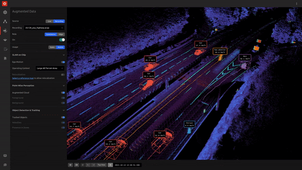
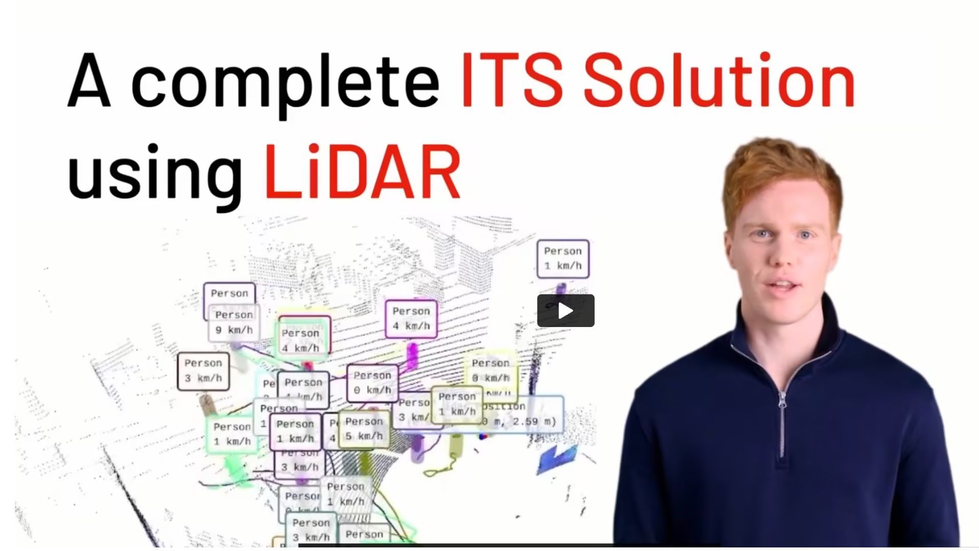
The combination of LiDAR and perception software is a perfect fit for effective traffic management. LiDAR collects 3D points to form a point cloud, and the software, like the one from Outsight, does unlimited data processing to generate actionable KPIs and alerts in a user-friendly dashboard and a stream of data that can be accessed through an API for integrators and solution providers.

LiDAR pulse rates usually vary from 10,000 to more than 2 million pulses per second, and a single laser pulse can generate multiple returns.
Software algorithms then process the output of LiDAR pulse returns to make sense of a specific environment, such as road traffic structure, in real-time and in any lightening conditions.
The next post provides an overview of some of the most important real-time LiDAR algorithms provided by Outsight's Software:
Earlier, teams manually labeled LiDAR data to identify key objects in the scan. Obviously, the effort was both time-consuming and laborious, requiring highly specialized knowledge and expertise.
Outsight's software can now help automate the classification process thanks to advancements in LiDAR sensors and 3D image processing. It can also record and monitor all information about an object trajectory, its dimensions and speed.
Conclusion
Today, LiDAR solutions not only help us sort through the complexity of sensors to identify nearby vehicles or infrastructure for further analysis but also provide critical indicators for traffic operators to understand dangerous intersections, detect when a vulnerable road user (VRU) wants to cross the street, or identify vehicles in the wrong direction.
Thanks to its accuracy, privacy compliance, and processing capacity in real-time, LiDAR-based software solutions are now being used in many different industries.
These industries include Intelligent Transportation Systems (ITS), People Flow monitoring, Industrial and Volume Measurement. Learn about each one of them in this article:

With the availability of advanced and cost-efficient solutions like Outsight, city planners now have access to a unique opportunity to collect and 24/7 monitor real-time, multimodal traffic data with ease, enabling informed decisions to improve safety.
Thanks to an effective and quick installation, LiDAR-based solutions can transform the way cities collect traffic data and pave the way for safer, more efficient transportation systems.
Download our ITS Cookbook to learn more about the traffic monitoring solutions offered by Outsight.


Newsletter
Receive the latest updates in your inbox.